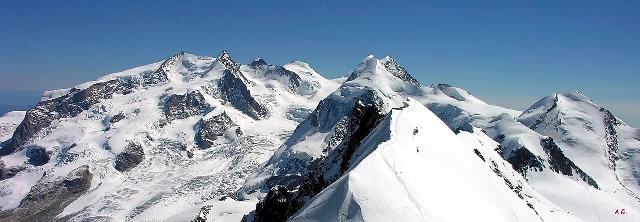
The Monte Rosa massif is Europe's second-highest mountain group and the largest cluster of 4,000 m summits in the Western Alps. On the Valdostan flank, shaped by the Lys and Gressoney valleys, active glaciers, Walser villages and a mountaineering tradition dating to the golden age of ascents coexist. From Dufourspitze (4,634 m) to the secondary summits of Lyskamm and Grenz, the Rosa forms a continuous belt of ice and rock visible from most of the region.
At a glance
- 12 summits above 4,000 m on the Alpine flank
- Walser culture in Gressoney, Ayas and the Lys basin
- Capanna Margherita: highest hut in Europe (Signalkuppe)
3D view of the massif
Interactive map with MapTiler terrain. Rotate and tilt to explore the mountain group.
Geology
The Monte Rosa basement consists of gneiss and micaschists of the Austroalpine domain, intensely metamorphosed during Alpine collision. Above, Penninic cover includes limestones, marbles and ophiolite zones. The Lys, Indren and Grenz glaciers shape hanging valleys, Würm moraines and still-evolving proglacial deposits. Along Alta Via 1, sharp contacts between crystalline rocks and Penninic sediments are visible in outcrops above Gressoney and Ayas.
History and alpine culture
Historic Rosa ascents started from Gressoney and Alagna: Signalkuppe saw Capanna Margherita built in 1893, still Europe's highest hut today. Walser culture — Titsch language, timber architecture and transhumance — shaped the Lys valley villages. During the First World War the massif ridges were fortified; remains of positions are still visible above 3,500 m.
Trails and routes
Alta Via 1 crosses the eastern Rosa flank from Gressoney to Ayas, with stages at Colle di Nana, Colle di Cignana and Colle di Valcournera. The Monte Rosa Tour is a high-mountain loop linking Gressoney, Ayas, Valtournenche and the Swiss Valais. Hiking trails reach alpine pastures, glacial lakes and viewpoints below the four-thousanders without mountaineering gear, but many sections are graded EE for exposure and elevation gain.
All summits
Dufourspitze (Monte Rosa)
4634m
Highest summit of the Monte Rosa massif and second peak in the Alps. From the Valdostan side of Gressoney and Ayas, the Lys glaciers and the belt of 4,000 m summits framing the alpine hub are clearly visible.
Nordend
4609m
Second-highest summit on Monte Rosa, on the Italian–Swiss watershed. It dominates the Gorner Glacier basin and the panorama toward Zermatt and the Matterhorn.
Zumsteinspitze
4563m
Summit between Colle Gnifetti and Dufourspitze, reached by mountaineering routes from the Gressoney side. Gneiss bedrock and perennial glaciers define this sector.
Signalkuppe (Punta Gnifetti)
4554m
Home to Capanna Margherita, the highest hut in Europe. A privileged viewpoint over Lyskamm, Monte Rosa and the Matterhorn chain.
Lyskamm (West summit)
4527m
Long, sharp ridge between Gressoney and Valais, nicknamed the “man-eater” for its unstable cornices. Referenced on Monte Rosa Tour stages.
Lyskamm (East summit)
4520m
Second summit on the Lyskamm ridge, separated by an exposed notch on the col. The Lys and Grenz glaciers frame the north face toward the Swiss flank.
Parrotspitze
4432m
Monte Rosa summit on the Italian side, linked to routes from Colle del Lys. Wide views over the Walser valleys of Gressoney.
Ludwigshöhe
4341m
Secondary Monte Rosa summit along the ridge toward Parrotspitze. Metamorphic basement rocks and active glaciers on the south flank.
Vincent Pyramid
4215m
Pyramidal summit above Gressoney-La-Trinité, between Balmenhorn and Colle del Lys. Gneiss spire and perennial glaciers visible from the Walser basins.
Balmenhorn
4167m
Rocky dome between Vincent Pyramid and Colle del Lys, known for the Balmen bivouac and views over the Lys Glacier. Penninic basement metamorphic rocks.
Schwarzhorn (Monte Rosa)
4075m
Last 4,000 m summit on the south-eastern Monte Rosa sector, above Alagna and the Bors Glacier. Dark gneiss and mica schist bedrock.
Giordani peak
4046m
Border summit between Alagna and Macugnaga, the last 4,000 m peak on Monte Rosa toward the east. Views over Val Sesia and the Matterhorn faces.