Trail guide
The 10 most spectacular alpine lakes in Aosta Valley
Guide to the ten finest high-altitude lakes in Aosta Valley — Rutor, Miage, Arpy, Chamolé, Loie and more, with linked hikes.
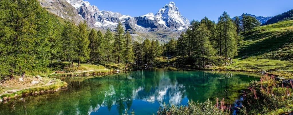
There is a moment, while walking towards a high-altitude lake, when the landscape changes register. The trail leaves the forest behind, the sound of the stream fades, the air grows thinner and suddenly — often after one last switchback — a sheet of water appears, set among rocky walls or glacial moraines. In just over three thousand square kilometres, Aosta Valley concentrates one of the highest densities of accessible alpine lakes in the western Alps: basins formed by retreating glaciers, naturally dammed tarns, mirrors suspended above two thousand five hundred metres that change colour with the hour of the day, with the wind and with the season.
This guide does not list "the easiest lakes" or "the most Instagrammable" ones — terms that often mean queues and disappointment. It offers ten lakeside destinations with their official linked trail, all featured in the Sentieri VdA catalogue, chosen for geological variety, route quality and the possibility of combining several basins in a single weekend. Each lake tells a different glacial story; walking up to it means reading the mountain like a geologist, even without knowing it.
Valdostan lakes are not natural swimming pools: the water is freezing, and the weather at altitude can change within an hour. Always check the trail pages for difficulty, elevation gain and the season when the route is passable.
Why alpine lakes fascinate us
Glacial morphology has been shaping Aosta Valley for two million years. During the ice ages, masses of ice tens of kilometres wide carved out valleys, carried debris and left behind moraines that today dam streams to form lakes. The turquoise or emerald water we see comes from the suspension of "rock flour" — extremely fine particles eroded by the glacier — which scatters blue light. When the glacier disappears entirely, the lake may turn green or transparent: every basin is a thermometer of alpine climate change.
1. Lago Rutor — the crown of Valgrisenche
The trail to Lago Rutor, the second stage of the Tour del Rutor, leads to an amphitheatre of glaciers, waterfalls and walls that close off the valley like a natural theatre. The emerald-coloured water, fed by the glacier of the same name, is among the most intense in the region: the contrast with the grey rock and the permanent snow creates a palette that French and Italian mountain guides have been citing for decades.
The difficulty is E, with the climb from Rifugio Deffeyes across moraines and alpine meadows. A practical tip: stay overnight at the Deffeyes the evening before, so that in the morning you reach the lake with the low-angled light that brings out the colour of the water. In August the Rutor glacier is still visible above the basin; you will hear the rumble of seracs breaking off if the silence allows it.
Valgrisenche is a side valley accessible from La Thuile, historically linked to hydroelectric power and to seasonal livestock movements. Lago Rutor is its jewel: a destination that alone justifies a week on the full tour, yet also doable in a single day by fit hikers. Bring sunglasses: the reflection off the water and the snow is intense.
2. Lago Rutor–Rifugio Verney — the full loop
For those who want to extend the Rutor experience, stage 3 Rutor–Verney links the lake to the Rifugio Chalet du Lac du Verney with panoramas that take in the Rutor, the Grandes Jorasses in the distance and the valleys descending towards France. It is an E day that turns the visit "to the lake" into a traverse: you walk over moraines, cross bridges over glacial streams, and descend towards the Verney with the profile of Mont Blanc emerging to the west.
The Verney is a refuge with an "end-of-tour" character: many hikers use it to close the Rutor loop before heading back down to La Thuile. The cuisine is Valdostan, the atmosphere homely. The tip: check the state of the glacier and the bridges early in the season; the stage may require variants if snow lingers on the minor passes.
Why include two stages of the same tour? Because Lago Rutor seen on the way up and the Rutor–Verney route seen as a traverse are two complementary experiences: the first is contemplation, the second is walking. Together, they tell the story of Valgrisenche better than any postcard.
3. Lago Blu — the jewel of Blanchard
The Blanchard–Lago Blu trail climbs from 1731 to 2297 metres in just 4.2 kilometres: the name ("Blue Lake") is no exaggeration. The basin, in the central Valdostan valley, is one of the most photogenic lakes in the region — and for that reason one of the most crowded on August weekends. The solution: set off at dawn on a Tuesday in July, or in September when the larches around the lake turn yellow.
Geologically, Lago Blu is a moraine-dammed lake: an ancient glacier deposited debris that blocked a stream, creating the basin. The deep, cold water reflects the sky with an intensity that ranges from turquoise to cobalt blue. The trail crosses coniferous woods and then opens onto the meadows: difficulty E, suited to hikers used to walking.
A practical tip: parking at Blanchard is limited. Arrive early or use the shuttles from the valley floor if available. At the lake, respect the environmental protection zone: no swimming, no fires, no litter left behind. The beauty of Lago Blu also depends on how much each of us contributes to preserving it.
4. Lac de Loie — above Cogne
From Lillaz, a hamlet of stone houses and Walser fountains, the route to Lac de Loie crosses the forest up to a lake with the glacial morphology typical of the Gran Paradiso Park. Valnontey and the Lillaz valley form a system of parallel valleys rich in basins: the Loie is less famous than the Djouan but just as striking, often quieter.
The trail is E, with a gradual elevation gain and the option of stopping halfway for a picnic at the edge of the woods. In spring and autumn the park's wildlife is more visible: ibex, chamois, marmots. The Loie lies in a hollow surrounded by peaks exceeding three thousand metres: the water, fed by snow and minor glaciers, stays cold even in July.
Combine it with Valnontey for a "water + wildlife" weekend: Saturday at the Loie, Sunday at Lago Djouan or vice versa. Cogne offers hotel and dining infrastructure; Lillaz is more intimate. Both lakes share the same granite geology of the Gran Paradiso massif, but offer different perspectives on the main glacier.
5. Lago del Miage — the glacier that mirrors itself
In Val Veny, on the Italian side of Mont Blanc, Visaille–Pont Combal–Lago del Miage is the lakeside trek par excellence: floating icebergs, moraines, the wall of the Miage as a scenic backdrop. The Miage glacier is one of the lowest in Europe — its glacial tongue descends to around 1800 metres — and the lake it forms at the end of the tongue often holds detached blocks of ice that float like natural sculptures.
The difficulty is E, with stretches on unstable moraine that require care. The trail passes by Pont Combal, a historic stone bridge crossed by hikers since the nineteenth century. Val Veny is a "noble" valley: less commercial than Val Ferret, just as majestic, with the profile of Mont Blanc changing with every kilometre.
Set off from Visaille in stable weather: Val Veny is exposed to clouds that build up in the afternoon. At Lago del Miage, observe the glaciers without approaching the tongue: the calving of blocks is unpredictable. Bring a telephoto lens: the contrast between blue ice, grey water and dark rock is reportage material.
6. Lac d'Arpy — the mirror of Mont Blanc
From Costablinaz, above Morgex, the trail to Lac d'Arpy offers one of the most iconic reflections in the western Alps when the wind drops in the morning. The basin, set in a hollow surrounded by larches and rocks, reflects Mont Blanc and the Grandes Jorasses with a symmetry that has served as a set for countless photographers and painters.
The trail is E, relatively short but with a concentrated elevation gain. The advice every guide repeats — and which we confirm — holds true: arrive by 8:00 in summer. After 10:00, the wind ripples the surface and the reflection vanishes. In September, with the first night frosts, the light is even clearer and the crowds are gone.
The Arpy valley has historically been a transit area towards the Little St Bernard Pass. The lake represents the "easy" destination of a network of trails that climb towards more demanding passes. If Lac d'Arpy wins you over, explore the variants towards the upper lakes — always consulting the trail pages for difficulty and conditions.
7. Lac de Chamolé — above Champorcher
The trail to Lac de Chamolé is an accessible classic (T/E) with flowering meadows and views over the Pennine Alps. Champorcher, a side valley of the Dora Baltea, retains a rural character far from the tourism of Courmayeur and Cogne: here you walk among pastures, abandoned huts and summer blooms that colour the meadows with gentians, anemones and orchids.
Lac de Chamolé lies in an open hollow: less "dramatic" than the Rutor or the Miage, but ideal for families looking for a "real" lake without EE difficulty. The trail is well marked, with the option to shorten the loop if the children tire. In July, bring sun cream: the meadows above the woods are exposed for hours.
The Champorcher valley shares with Val d'Ayas a Walser heritage and a still-living tradition of mountain pasturing. The Chamolé is a Sunday destination for local families: respect the pastures, close the gates, do not disturb the livestock. Here the mountain is still an economy, not just scenery.
8. Lac Money — the heart of the Cogne park
From Gimillan, a Walser hamlet above Cogne, Gimillan–Lac Money leads to a basin surrounded by the peaks of the Gran Paradiso. Less famous than the Djouan, just as striking and often quieter: many tourists stop at the first "well-known name", leaving the Money to the hikers who read maps.
The trail crosses woods and then meadows with views of the summits exceeding three thousand metres. Difficulty E, half a day at a relaxed pace. The Money — a name that comes from Franco-Provençal, not from the coin — sits in a position that allows variants towards minor passes and lakes for those who want to extend the day.
Gimillan is worth a visit even without climbing to the lake: the wooden houses, the fountains, the silence of the hamlet tell the Walser story better than a museum. Combine it with a night in Cogne and a second day at the Loie or the Djouan: three lakes, three perspectives on the Gran Paradiso.
9. Lac Mort — the suspended lake of Valpelline
The Place Moulin–Lac Mort trail starts from the valley floor of Valpelline, where the Place Moulin dam has created one of the largest reservoirs in Europe, and climbs to a lake with an evocative name, set among rocky walls. "Mort" — dead — does not signal danger: in Valdostan patois it suggests a remote, silent place, far from passing traffic.
The trek is E, with the climb through larch woods and then more mineral terrain. Valpelline is geologically different from the Mont Blanc valleys: here gneiss and calc-schists dominate, with darker colours, a "Nordic" landscape reminiscent of the Swiss Valais. Lac Mort is its purest expression: dark water, vertical walls, an echo that bounces between the rocks.
An ideal destination for those who love names and mineral landscapes more than postcard turquoise tarns. Set off with warm layers: the shade of the walls can keep things cool even on an August afternoon. Check the state of the trail early in the season: Valpelline holds snow at relatively low altitudes.
10. Laghi del Mont Avic — the lesser park
In the Mont Avic Park, the loop of the lakes and the Gran Lago is one of the most underrated lakeside itineraries in the region: nature, silence and clear waters far from the queues of the Gran Paradiso. Mont Avic, with its summit at 3006 metres, dominates a protected area smaller than the neighbouring Gran Paradiso but just as rich in alpine wildlife and flora.
The route is E, with the option of a loop that touches several basins in a day. The Mont Avic lakes are of glacial and dammed origin: small mirrors, often unnamed on tourist maps, that appear one after another like pearls on a necklace. The wildlife includes chamois, marmots and eagles; in autumn the larches around the basins create extraordinary chromatic contrasts.
Why close with a "lesser" park? Because Aosta Valley does not end where the posters end. Mont Avic requires an effort to get there — Champdepraz, the Cogne valley — but it repays you with authentic solitude. If you have already seen the Rutor and the Miage, these lakes will show you another face of the region.
Photography tip
Valdostan lakes change colour with the hour of the day and with the wind. For reflections — Arpy, Miage, Lago Blu — set off at dawn or within the first hours of the morning. For the intense blue of the Rutor and the glacial waters, favour 10:00–14:00 with clear skies and a high sun that penetrates deep. In windy conditions, aim for compositions with rocks in the foreground and rippled water: sometimes the "best" photo is not the one of the perfect reflection.
Always check the trail pages for the season when the route is passable: many passes remain snow-covered until July, and some upper lakes are accessible only from mid-summer.
An unconventional "three lakes" weekend
Valgrisenche (Rutor) + Val Veny (Miage) in two days, staying overnight in Courmayeur or La Thuile: two completely different glacial basins — one a high alpine lake, one a low glacial tongue — with zero overlap with the "easy" social-media rankings. Add a third day at Lac d'Arpy on the way back towards the valley floor: three lakes, three valleys, a weekend that tells the story of Valdostan geology better than an entire volume of maps.
| Lake | Approx. altitude | Best light |
|---|---|---|
| Rutor | 2400 m | Morning |
| Lago Blu | 2297 m | Midday |
| Miage | 2050 m | Dawn |
| Arpy | 2066 m | Early morning |
| Chamolé | 2300 m | Afternoon |
Photo credits
Cover: Unsplash — Lago Rutor and the glaciers of Valgrisenche. Image at /articoli/laghi-rutor.jpg.