Valle del Gran San Bernardo — Val d’Entremont
Tour des Combins — Stage 2: Saint-Rhémy-en-Bosses → Bourg-Saint-Pierre
19.9 km
+1116 m
−1155 m
9.5 h
Fitness level
Map & route
GPX track — verify on the ground before hiking
Description
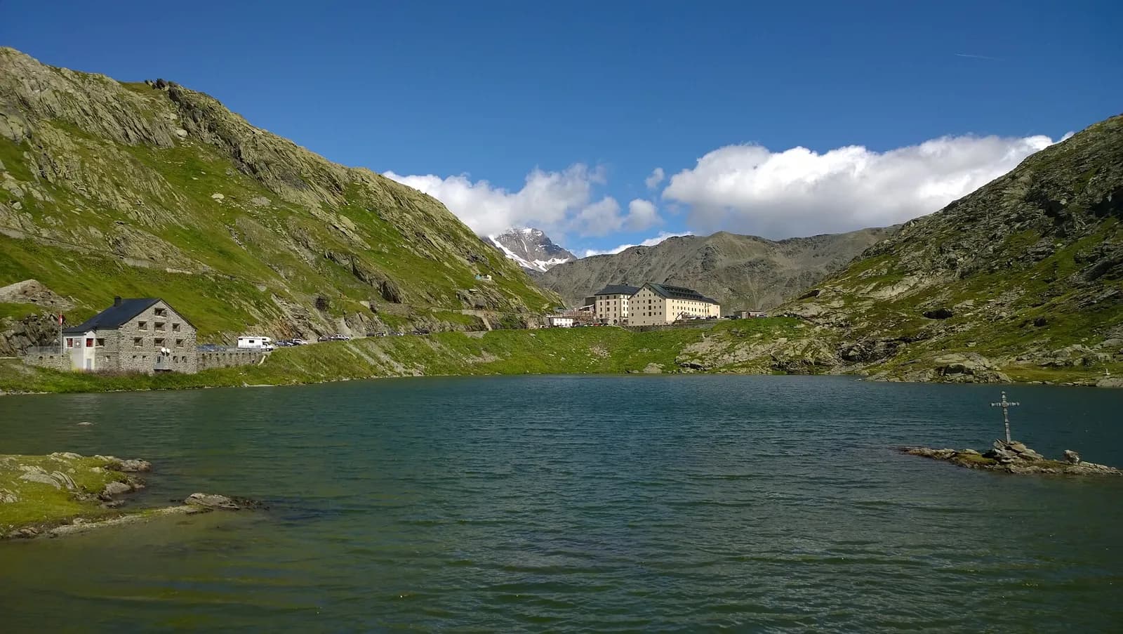
From Saint-Rhémy climb along the ancient Roman road of the Gauls to the Great St Bernard pass (2,473 m), with its thousand-year-old hospice and famous dogs. Then descend into Switzerland’s Val d’Entremont, through the Combe des Morts and pastures, to Bourg-Saint-Pierre (1,632 m).
You walk through history: the climb to the Great St Bernard follows the Roman road of the Gauls — cart ruts are still visible in the rock just below the pass — marched by Napoleon with forty thousand men in May 1800. At the hospice, founded by St Bernard in 1050 and continuously inhabited for nearly a thousand years, you can visit the baroque church, the museum and the kennels of the famous St Bernard dogs. The Swiss descent crosses the Combe des Morts and follows the torrent to Bourg-Saint-Pierre, whose Romanesque bell tower carries a thousand years of history.
Key points
Col du Grand Saint-Bernard
2473 m · 8.3 km from start
Earth sciences
Geology & landscape
The Grand Combin belongs to the Grand St Bernard nappe (middle Penninic): crystalline schists and gneisses of the Siviez-Mischabel zone, overlain to the south by the calcschists-with-ophiolites of the By valley. The great north wall above the Panossière hut shows the alternation of basement and carbonate cover; the Fenêtre de Durand is carved in the softer calcschists, ever the natural way between Bagnes and Valpelline.
History & culture
On the pass, the hospice founded by St Bernard of Menthon (~1050) has rescued travellers for nearly a thousand years; Charlemagne passed this way and, in May 1800, Napoleon with 40,000 men.
Water sources
Water at the stage's support points (Saint-Rhémy-en-Bosses, Hospice du Grand Saint-Bernard, Bourg-Saint-Pierre). On the high ground and at the passes springs are not guaranteed: fill bottles in the valley and at the huts.
Getting there
Cross-border stage: on the foreign sides local public transport applies (PostAuto in Switzerland, line buses in France/Piedmont). Check seasonal timetables; in peak season several access links run by reservation only.
Warnings
- Snowfields possible on the passes until early July
- Book overnight stops in peak season
Start & end
Start
Saint-Rhémy-en-Bosses
1532 m
Finish
Bourg-Saint-Pierre
1641 m
Refuges & bivouacs
Photo gallery
Adjacent stages
ACurated and verified by Andrea
Data source: Tour des Combins — itinerario ufficiale transfrontaliero · Traccia calcolata su rete sentieri OpenStreetMap (ODbL); verificare sul terreno
Last verified:
Valle del Gran San Bernardo — Val d’Entremont
Related trails
Same valley or similar routes — more hikes to explore.
Valle del Gran San Bernardo
High Route 1 — Stage 14: Rifugio Champillon → Saint-Rhémy-en-Bosses
Over Col Champillon (2709 m) with panoramic views from Mont Blanc to Gran Paradiso, followed by a long descent to Saint-Rhémy-en-Bosses in the historic upper Grand Saint-Bernard valley.
Valle del Gran San Bernardo
High Route 1 — Stage 15: Saint-Rhémy-en-Bosses → Rifugio Frassati
A steady climb through the Merdeux basin to Rifugio Frassati at 2540 m, the last overnight stop before tackling Col Malatrà (2925 m), the highest pass on the entire Alta Via 1.
Valle del Gran San Bernardo
Allein - Mont Saron
From Allein village, the climb to Mont Saron crosses forest, alpine pastures and a summit ridge on the watershed between Gran San Bernardo and Valpelline: 1434 m ascent for fit hikers.
Valle del Gran San Bernardo
Ayez - Genevrey
2.9 km · +477 m · E — from Ayez to Genevrey (Great St Bernard Valley).