High Route 1 — Stage 15: Saint-Rhémy-en-Bosses → Rifugio Frassati
10 km
+905 m
−20 m
4 h
Fitness level
~2900 kcal estimated
Elevation profile
Map & route
Download GPXOfficial GPX track — Aosta Valley Region / lovevda.it
Description
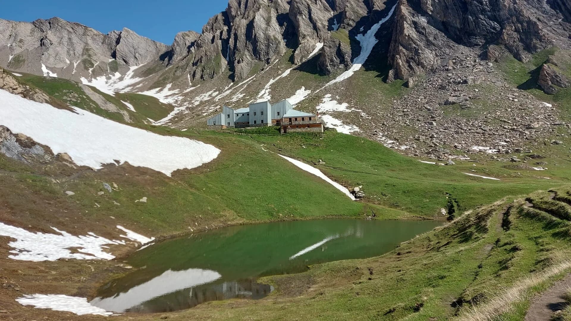
Stage fifteen climbs from Saint-Rhémy-en-Bosses toward Rifugio Pier Giorgio Frassati, the overnight stop immediately below the ascent to Col Malatrà, the highest pass on the entire Alta Via 1. The route rises through the Merdeux basin on a path that crosses well-maintained meadows, streamside vegetation and open slopes, with the outline of Petit Saint-Bernard visible to the west. The 905 m of positive elevation is distributed evenly across the distance, making this a stage of duration rather than acute difficulty. Rifugio Pier Giorgio Frassati (2540 m) is dedicated to the young Turinese mountaineer beatified by Pope John Paul II in 1990, known as the man of the beatitudes for his life of service and love of the mountains. The hut provides comfortable accommodation with meals in a modern, welcoming setting. An overnight here is strategically essential: the ascent to Col Malatrà (2925 m) and the long descent into Val Ferret the following morning demand the earliest departure of the entire route.
Key points
Saint-Rhémy-en-Bosses
1600 m · 0 km from start
Stage start, last services
Conca di Merdeux
2100 m · 5.5 km from start
Pastoral basin with Petit Saint-Bernard views
Rifugio Pier Giorgio Frassati
2540 m · 10 km from start
Stage finish, base for Col Malatrà
Earth sciences
Geology & landscape
The climb into Merdeux basin crosses Penninic calcschists and micaschists with marble and quartzite outcrops. The Austroalpine basement outcrops above 2200 m with augen gneiss and chloritic phyllites. Würmian glacial deposits shape the basin with rebuilt moraines and lacustrine sediments. Slopes display colluvial deposits and active landslides on decomposed carbonate substrate. Distantly toward Petit Saint-Bernard, Mont Blanc massif metamorphic units outcrop. Pastures develop on deep soils from decomposed moraines rich in organic matter.
History & culture
Rifugio Frassati is dedicated to Blessed Pier Giorgio Frassati, a young Turinese mountaineer. The basin is still used for transhumance to summer pastures.
Water sources
Services in Saint-Rhémy. Springs in Merdeux basin. Water at Rifugio Frassati.
Getting there
VITA bus to Saint-Rhémy from Aosta. Summer connection toward Etroubles.
Parking
Parcheggio a Saint-Rhémy centro.
Warnings
- Overnight essential before Col Malatrà
- Snow possible until July above 2400 m
Nearby peaks
Start & end
Start
Saint-Rhémy-en-Bosses
1613 m
Finish
Rifugio Pier Giorgio Frassati
2506 m
Refuges & bivouacs
Photo gallery
Flora along the trail
Wildlife to spot
Themes and features
Adjacent stages
ACurated and verified by Andrea
Data source: Catasto Sentieri Regione VdA + thealps.com (D+ verificato) — km stimati · Open data — DGR 899/2014
Last verified:
Valle del Gran San Bernardo
Related trails
Same valley or similar routes — more hikes to explore.
Valle del Gran San Bernardo
Allein - Mont Saron
7.5 km · +1434 m · E — from Chef-lieu to Mont Saron (Great St Bernard Valley).

Valle del Gran San Bernardo
Anello dei Gemelli della Mologna
8.9 km · +996 m · EEA — from Niel to Niel (Great St Bernard Valley).
Valle del Gran San Bernardo
Area pic-nic Plan Veny - Lac du Breuillat
3.6 km · +420 m · E — from Area pic-nic Plan Veny to Lac du Breuillat (Great St Bernard Valley).
Valle del Gran San Bernardo
Area pic-nic Plan Veny - Rifugio Monzino
3.4 km · +997 m · EEA — from Area pic-nic Plan Veny to Rifugio Monzino (Great St Bernard Valley).