Trail guide
The best hikes in the Great St Bernard Valley
The best hikes in the Great St Bernard Valley: 13 selected trails with difficulty, distance, elevation gain and links to the route pages. Sentieri VdA guide.
The historic route to the Great St Bernard Pass, between the thousand-year-old hospice and the By basin: border trails, alpine pastures, views of the Combin and stages of Alta Via 1 between Saint-Rhémy and Etroubles.
This guide gathers the best trails in the area, all from the Sentieri VdA catalogue: for each one you get the CAI difficulty, distance, elevation gain and a direct link to the route page with map, elevation profile, photos and the day’s weather.
Every itinerary below uses real data from the Aosta Valley trail registry — waymark numbers, distances and elevation gain — and links to the full page with satellite map, GPX track, elevation profile and the nearest town’s weather. Always check conditions before setting off: at altitude the weather changes fast and some passes stay snow-covered into early summer.
Selected trails
Tour des Combins — Stage 1: Ollomont → Saint-Rhémy-en-Bosses
18.6 km · +1635 m · EE — from Ollomont to Saint-Rhémy-en-Bosses.
From Ollomont climb to the luminous By basin, a pastoral amphitheatre below the Grand Combin, and cross the Col Champillon (2,709 m) beside the Letey-Champillon hut. A long descent through pastures and woods reaches Saint-Rhémy-en-Bosses (1,632 m), home of the Jambon de Bosses ham.
Tour des Combins — Stage 2: Saint-Rhémy-en-Bosses → Bourg-Saint-Pierre
19.9 km · +1116 m · E — from Saint-Rhémy-en-Bosses to Bourg-Saint-Pierre.
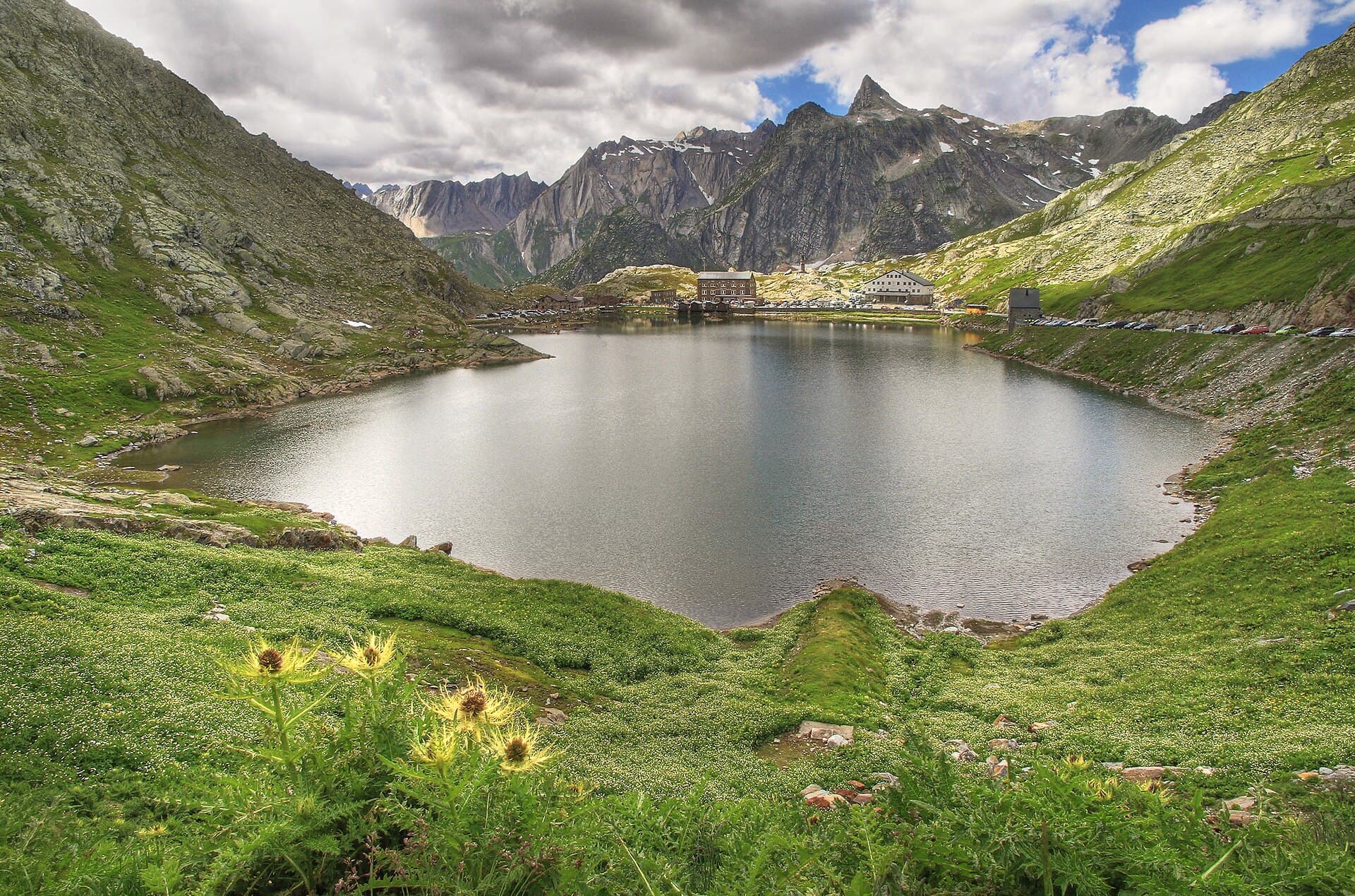
From Saint-Rhémy climb along the ancient Roman road of the Gauls to the Great St Bernard pass (2,473 m), with its thousand-year-old hospice and famous dogs. Then descend into Switzerland’s Val d’Entremont, through the Combe des Morts and pastures, to Bourg-Saint-Pierre (1,632 m).
High Route 1 — Stage 15: Saint-Rhémy-en-Bosses → Rifugio Frassati
10 km · +905 m · E — from Saint-Rhémy-en-Bosses to Rifugio Pier Giorgio Frassati.
Stage fifteen climbs from Saint-Rhémy-en-Bosses toward Rifugio Pier Giorgio Frassati, the overnight stop immediately below the ascent to Col Malatrà, the highest pass on the entire Alta Via 1.
High Route 1 — Stage 14: Rifugio Champillon → Saint-Rhémy-en-Bosses
14 km · +522 m · E — from Rifugio Champillon to Saint-Rhémy-en-Bosses.
Stage fourteen carries the Alta Via 1 from Rifugio Champillon to the upper Grand Saint-Bernard valley, one of the great historic communication routes between Italy and Switzerland.
High Route 1 — Stage 16: Rifugio Frassati → Rifugio Bonatti via Col Malatrà
10 km · +430 m · EE — from Rifugio Pier Giorgio Frassati to Rifugio Walter Bonatti.
Stage sixteen is the most alpine stretch of the entire Alta Via 1: it climbs to Col Malatrà at 2925 metres — the highest point of the whole route — and descends into Val Ferret to Rifugio Walter Bonatti.
Colle Grand Saint Bernard - Col Grand Ferret
26.3 km · +2016 m · E — from Colle Grand Saint Bernard to Col Grand Ferret.
Colle Grand Saint Bernard - Col Grand Ferret is an official trail from the Aosta Valley trail registry (code TSB_S1). The route lies in the municipality of Sarre, in the Central Valley. From Colle Grand Saint Bernard (2449 m) to Col Grand Ferret (2525 m): 26.3 km with +2016 m of elevation change, difficulty E (CAI scale).
Cré - Pointe Chaligne
9.1 km · +1701 m · E — from Cré to Pointe Chaligne.
Cré - Pointe Chaligne is an official trail from the Aosta Valley trail registry (code 30_S2). The route lies in the municipality of Gressan, in the Central Valley. From Cré (894 m) to Pointe Chaligne (2611 m): 9.1 km with +1701 m of elevation change, difficulty E (CAI scale).
Gignod - Pointe Chaligne
8.9 km · +1661 m · E — from Gignod to Pointe Chaligne.
Gignod - Pointe Chaligne is an official trail from the Aosta Valley trail registry (code 30_S3). The route lies in the municipality of Gressan, in the Central Valley. From Gignod (975 m) to Pointe Chaligne (2611 m): 8.9 km with +1661 m of elevation change, difficulty E (CAI scale).
Echevennoz - Pointe Chaligne
6.5 km · +1468 m · E — from Echevennoz to Pointe Chaligne.
Echevennoz - Pointe Chaligne is an official trail from the Aosta Valley trail registry (code 26_S2). The route lies in the municipality of Fénis, in the Central Valley. From Echevennoz (1256 m) to Pointe Chaligne (2611 m): 6.5 km with +1468 m of elevation change, difficulty E (CAI scale).
Allein - Mont Saron
7.5 km · +1434 m · E — from Chef-lieu to Mont Saron.
From the Chef-lieu of Allein (1248 m), the heart of this village in the Gran San Bernardo valley, trail no. 24 climbs steadily toward Mont Saron (2682 m), the landmark mountain that divides the Valpelline to the east from the Gran San Bernardo valley to the west.
Etroubles - Col Champillon
6.5 km · +1376 m · E — from Etroubles to Col Champillon.
Etroubles - Col Champillon is an official trail from the Aosta Valley trail registry (code 26_S12). The route lies in the municipality of Fénis, in the Central Valley. From Etroubles (1339 m) to Col Champillon (2707 m): 6.5 km with +1376 m of elevation change, difficulty E (CAI scale).
Etroubles, Vachery - Col Barasson Est
6.7 km · +1353 m · E — from Vachery to Col Barasson Est.
Etroubles, Vachery - Col Barasson Est is an official trail from the Aosta Valley trail registry (code 26_S5). The route lies in the municipality of Fénis, in the Central Valley. From Vachery (1339 m) to Col Barasson Est (2687 m): 6.7 km with +1353 m of elevation change, difficulty E (CAI scale).
Saint-Léonard - Punta Valletta
5.6 km · +1334 m · E — from Saint-Léonard to Punta Valletta.
Saint-Léonard - Punta Valletta is an official trail from the Aosta Valley trail registry (code 64_S6). The route lies in the municipality of Sarre, in the Central Valley. From Saint-Léonard (1531 m) to Punta Valletta (2802 m): 5.6 km with +1334 m of elevation change, difficulty E (CAI scale).
Explore the full catalogue on the Trails page and plan your next hike in the Aosta Valley.
Cover photo: Ximonic, Simo Räsänen · GFDL