Trail guide
Best little-known hikes in Aosta Valley
Trails off the mainstream lists in Aosta Valley — alternative AV stages, Valgrisenche, Ollomont and side valleys.
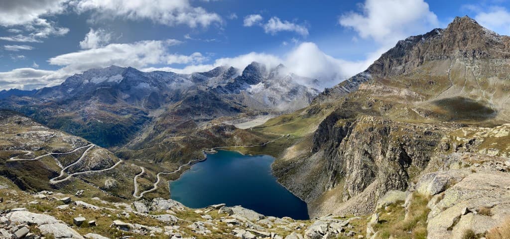
There is an Aosta Valley that never appears on glossy covers: that of the side valleys, of the Alta Via stages walked by a handful of trekkers a month, of the Walser passes where the ancient German language survives in the names of the meadows and the surnames of the families. It is not «secret» in the elitist sense of the word — it is simply off the radar of the guides that have to sell Bonatti, the Matterhorn and Courmayeur at all costs. And yet, for those willing to move thirty kilometres away from the tourist centre of gravity, the reward is silence, authenticity and the strange satisfaction of coming across a trail that «no one knows» — except the shepherds, the CAI and those who have lived there for generations.
This guide gathers eight treks from the Sentieri VdA catalogue that fall into this category: routes that are verified, mapped, walkable — but absent from the mainstream lists. We have grouped them by geographic and cultural threads, not by ranking: because here the «why» counts more than «how beautiful it is on a scale of one to ten».
The Walser world of Gressoney: Barma, Niel and the «hidden» descent
The Walser culture — a high-medieval alpine colonisation that set out from Switzerland — left an indelible mark on the Aosta Valley in the Val d'Ayas and the Valle di Gressoney. The meadows above Gaby and Gressoney are not just pastures: they are a linguistic landscape, an architecture of wood and stone, the memory of transhumances that precede the automobile by a millennium.
Stage 4 of the Alta Via 1, Barma–Niel crosses this world with ten kilometres of E difficulty, a modest elevation gain on the climb and almost a thousand metres of descent towards the hamlet of Niel. The Rifugio Barma, the starting point, dominates the valley with that sobriety that distinguishes the authentic Walser refuges — no boutique design, only wood, warmth and peaks. The descent towards Niel offers views over Monte Rosa that, on a clear day, make any other destination in the region seem superfluous.
But Niel is not just a point of arrival: it is a crossroads. Stage 5, Niel–Gressoney-Saint-Jean is an EE day of over eighteen kilometres — not for everyone, but perfect as a challenge for hikers who want to discover the Walser side without the crowds. Woods, streams, abandoned pastures that tell of the end of a pastoral economy: to walk here means to read the mountain as a historical text, not as a backdrop.
The deep Valpelline: Oyace, Ollomont and the Gran San Bernardo
The Valpelline is the «border» valley par excellence: here the Aosta Valley looks towards Monte Rosa and the Gran Combin, towards passes that for centuries linked Italy to Switzerland. Oyace and Ollomont are villages that mass tourism has not yet absorbed — or that have absorbed it sparingly, keeping slow rhythms and concrete hospitality.
Stage 12 of the Alta Via 1, Oyace–Ollomont via Col Brison is one of the most authentic transitions of the entire traverse: twelve kilometres, difficulty EE, crossing the Col Brison at over 2600 metres. Marmots whistling from the boulders, pastures where livestock still grazes in regulated freedom, a silence that doesn't need to be defended. Here the mountain «works» — in the sense that it is not a fenced park but inhabited territory, with all the complexities that entails.
From Ollomont, stage 13 towards the Rifugio Champillon climbs towards the Gran San Bernardo basin over nine and a half kilometres and difficulty E. The Combin stands out to the south-west; to the north, the Valais Alps. It is «border» trekking in the most literal sense: every step moves through a political and natural geography that has shaped Aosta Valley identity.
Valgrisenche and La Thuile: the Alta Via 2 that no one tells about
While Courmayeur and Val Veny absorb most of the attention on the southern side of Mont Blanc, the Valgrisenche and the La Thuile district guard stretches of the Alta Via 2 of a silent beauty. The Place Moulin dam — engineering and landscape in tension — marks the entrance to a valley that many cross by car without imagining the trails above.
Stage 2 of the AV2, Elisabetta–La Thuile descends from the Rifugio Elisabetta — already in the heart of Mont Blanc — towards La Thuile over twelve kilometres of E difficulty. Woods, pastures, the gradual transition from the realm of ice to the valley floor: a bridge between two worlds that few hikers walk compared to the Courmayeur side.
From La Thuile, stage 3 towards Promoud explores sixteen kilometres and almost 1500 metres of positive elevation gain — a full day (E, about seven hours) in a side valley that generic guides mention in a single line or ignore altogether. Exposed geology, waterfalls, meadows where the Valgrisenche shows its wildest face: not as spectacular as the Matterhorn, but just as real.
Champorcher and the eastern side of the park
Champorcher closes the Gran Paradiso system to the east. Stage 12 of the AV2, Dondena–Champorcher is a short descent — six kilometres, difficulty E, about two hours — which for those walking the entire traverse is almost an epilogue, but for those seeking a standalone outing is an immersion in the least touristy side of the park. Larch woods, valleys that open towards Piedmont, refuges where booking doesn't require three months' notice.
High altitude and solitude: the Tour del Gran Combin
For those with legs and head suited to EE, stage 3 of the Tour Gran Combin, Colle del Gran San Bernardo–Combin de Tsessiöne offers solitude and ridges above Ollomont that make you forget the queues at the Bonatti. Twelve kilometres, crossing the Colle del Gran San Bernardo — a historic alpine pass travelled by armies and pilgrims — and a climb towards the Combin de Tsessiöne: trekking for experienced hikers who hate queues and love the austere mountain.
Why these trails «work»
We didn't build this list to fill a web page. We selected routes that share common features: low footfall even in August, an authentic landscape not repeated endlessly on social media, a refuge infrastructure that is present but less booked, geographic variety covering Walser, Valpelline, Valgrisenche and Champorcher. They are trails that reward those willing to move away from the centre — not out of snobbery, but because the Aosta Valley is small in surface area and immense in depth.
An «anti-mainstream» weekend combo could be: Saturday the Oyace–Ollomont stage, Sunday La Thuile–Promoud. Two valleys, zero overlap with the «top ten» rankings of the travel magazines. Two days to discover that the less famous mountain is often the most generous mountain.
How to prepare
Always consult the linked data sheets for CAI difficulty, elevation gain, seasonality and equipment. The EE stages require a sure step at altitude, orientation and respect for the weather. The Walser and Valpelline refuges accept bookings with less notice than the «big names», but July and August remain crowded months — better to call. Bring thermal layers even in mid-August: the Valpelline and the Valgrisenche know abrupt temperature changes in the afternoon.
Women, men and mountains: who walks these valleys
Oyace and Ollomont do not appear in viral reels — and perhaps that's for the better. Here the families of shepherds know every trail by its dialect name; the refuges fill up with AV1 trekkers who have chosen the «slow» traverse, the one that avoids the most crowded stretches. Stage 12 Oyace–Ollomont crosses a landscape where the border between Italy and Switzerland is more an idea than a fence: you walk in a geography shared for centuries.
The Valgrisenche, with its Place Moulin dam, divides opinion: engineering that has altered the landscape, yes — but also a valley that has preserved its trails and silence thanks to low population density. Stage 3 La Thuile–Promoud explores precisely that side valley that many cross by car without raising their eyes. Waterfalls, meadows, exposed rock: a geological chapter walkable at human pace.
When to go and how to combine them
| Area | Ideal season | Watch out for |
|---|---|---|
| Gressoney Walser | July–September | Stage 5 EE: experts only |
| Valpelline | June–September | Col Brison: snow until July |
| Valgrisenche | July–August | Promoud: long day |
| Champorcher | June–September | Dondena: short but steep |
A five-day itinerary for those wanting a complete taste: day 1 Barma–Niel; day 2 rest or Niel–Gressoney (EE only); day 3 Oyace–Ollomont; day 4 Ollomont–Champillon; day 5 Elisabetta–La Thuile as a closing towards civilisation. A softer alternative: two separate weekends — Walser one month, Valpelline the next.
Why «little-known» doesn't mean «dangerous»
These trails are signposted, mapped, maintained by the CAI and the regional cadastre. «Little-known» indicates low tourist footfall, not absence of maintenance. Consult the data sheets for difficulty, equipment and variants. Bring a map or GPX even where the waymarking seems obvious: the mist in the Valpelline and the Valgrisenche doesn't ask permission.
Refuges and bookings: the logistics of the «little-known»
One of the silent advantages of these itineraries is the availability in the refuges. The Rifugio Barma, Champillon, Promoud (bivouac or nearby structures), Dondena — rarely require booking three months in advance like the Bonatti or Elisabetta. Call anyway: July and August remain peak months, and a «free place» today may not be one tomorrow.
For the EE stage of the Tour Gran Combin, Col–Tsessiöne, check the conditions of the pass and residual snow: the Colle del Gran San Bernardo is also driveable in summer, but the trails above Ollomont have a truly alpine character.
A note on «mainstream»
Bonatti, the Matterhorn, Courmayeur — they deserve their fame. But the entire Aosta Valley measures barely 3263 km²: focusing only on the centre means ignoring two thirds of the territory. Gressoney Walser, Valpelline, Valgrisenche and Champorcher are that silent majority. To walk them is not an escape from tourism: it is a completion of the picture.
The little-known Aosta Valley doesn't demand expedition equipment: it asks for curiosity, respect for those who live in the valleys, and the patience to walk without having to document every step. The eight treks we have described — from the Walser Alps to the Combin, from Oyace to Promoud — are invitations to discover that depth. The trail does the rest.
Photo credits
- Cover (Aosta Valley side valley): Wikimedia Commons, CC BY — Sentieri VdA archive
- Valpelline and Oyace–Ollomont pastures: regional trail catalogue, Sentieri VdA reworking
- Valgrisenche and Place Moulin dam: mountain photographic archive, free licence