High Route 1 — Stage 15: Saint-Rhémy-en-Bosses → Rifugio Frassati
Advertencias
- Overnight essential before Col Malatrà
- Snow possible until July above 2400 m
 1 / 2
1 / 210 km
+905 m
−20 m
4 h
Nivel físico
~2900 kcal estimadas
Mapa y ruta
Traza GPX oficial — Región Valle de Aosta / lovevda.it
Descripción
Puntos clave
Salida
Saint-Rhémy-en-Bosses · 1613 m
Llegada
Rifugio Pier Giorgio Frassati · 2506 m
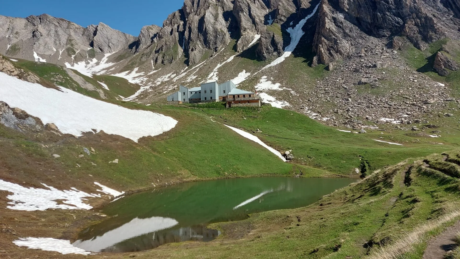
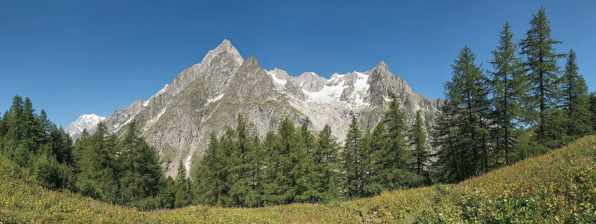
Stage fifteen climbs from Saint-Rhémy-en-Bosses toward Rifugio Pier Giorgio Frassati, the overnight stop immediately below the ascent to Col Malatrà, the highest pass on the entire Alta Via 1. The route rises through the Merdeux basin on a path that crosses well-maintained meadows, streamside vegetation and open slopes, with the outline of Petit Saint-Bernard visible to the west. The 905 m of positive elevation is distributed evenly across the distance, making this a stage of duration rather than acute difficulty. Rifugio Pier Giorgio Frassati (2540 m) is dedicated to the young Turinese mountaineer beatified by Pope John Paul II in 1990, known as the man of the beatitudes for his life of service and love of the mountains. The hut provides comfortable accommodation with meals in a modern, welcoming setting. An overnight here is strategically essential: the ascent to Col Malatrà (2925 m) and the long descent into Val Ferret the following morning demand the earliest departure of the entire route.
Puntos clave
Saint-Rhémy-en-Bosses
1600 m · 0 km from start
Stage start, last services
Conca di Merdeux
2100 m · 5.5 km from start
Pastoral basin with Petit Saint-Bernard views
Rifugio Pier Giorgio Frassati
2540 m · 10 km from start
Stage finish, base for Col Malatrà
Ciencias de la Tierra
Geología y paisaje
The climb into Merdeux basin crosses Penninic calcschists and micaschists with marble and quartzite outcrops. The Austroalpine basement outcrops above 2200 m with augen gneiss and chloritic phyllites. Würmian glacial deposits shape the basin with rebuilt moraines and lacustrine sediments. Slopes display colluvial deposits and active landslides on decomposed carbonate substrate. Distantly toward Petit Saint-Bernard, Mont Blanc massif metamorphic units outcrop. Pastures develop on deep soils from decomposed moraines rich in organic matter.
Historia y cultura
Rifugio Frassati is dedicated to Blessed Pier Giorgio Frassati, a young Turinese mountaineer. The basin is still used for transhumance to summer pastures.
Fuentes de agua
Services in Saint-Rhémy. Springs in Merdeux basin. Water at Rifugio Frassati.
Cómo llegar
VITA bus to Saint-Rhémy from Aosta. Summer connection toward Etroubles.
Cumbres cercanas
Refugios y vivacs
Galería de fotos
Photos are published immediately. JPG/PNG/WebP, max 6 MB.
Flora del sendero
Fauna que observar
Temas y características
Etapas contiguas
AEditado y verificado por Andrea Rama
Fuente de datos: Catasto Sentieri Regione VdA + thealps.com (D+ verificato) — km stimati · Open data — DGR 899/2014
Última verificación:
Valle del Gran San Bernardo
Senderos relacionados
Mismo valle o rutas similares — más excursiones por descubrir.
Valle del Gran San Bernardo — Val d’Entremont
Tour des Combins — Stage 2: Saint-Rhémy-en-Bosses → Bourg-Saint-Pierre
The Great St Bernard, two thousand years of history on foot.
Valle del Gran San Bernardo
Allein - Mont Saron
From Allein village, the climb to Mont Saron crosses forest, alpine pastures and a summit ridge on the watershed between Gran San Bernardo and Valpelline: 1434 m ascent for fit hikers.
Valle del Gran San Bernardo
Ayez - Genevrey
2.9 km · +477 m · E — from Ayez to Genevrey (Great St Bernard Valley).
Valle del Gran San Bernardo
Bivio strada sterrata per Jovençan - Lacs de Dziule
From Jovençan track junction (1855 m) to the glacial Lacs de Dziule (2553 m) in upper Valdigne: 5.8 km, +702 m. Open cirque scenery. E.