130 km
8,500 m+
17 stages
12–14 days
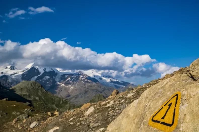
There is a thread that stitches the Aosta Valley together from east to west, suspended between two and three thousand metres, always within sight of the great glaciers. It is the High Route 1, the 'Way of the Giants': a journey that starts from the vine-clad hills above Donnas and, stage after stage, leads to the foot of Mont Blanc, passing beneath Monte Rosa, the Matterhorn and the Grand Combin. It is not a race: it is a slow approach to the colossi of the Alps, one pass at a time.
High Route 1 runs along the orographic left side of the valley, the south-facing one that overlooks the border chain. It is a multi-stage route linking refuges and historic villages, designed to be walked over several days with overnight stays at altitude: each stage crosses a pass and drops into a new side-valley, in an alternation of demanding climbs and descents to the alpine pastures. The panorama changes constantly, but the great four-thousanders always remain in the background, like cardinal points.
It is a route of hiking difficulty (E/EE) but physically demanding for its overall length and daily height gains: it calls for fitness, familiarity with altitude and proper equipment. The ideal season runs from late June to mid-September, when the passes are clear of snow and the refuges open. It can be walked in full as a multi-day traverse, or you can pick single stages as day hikes, starting from valley floors reachable by car or public transport.
Below you'll find all the official stages in order, each with its own page: distance, height gain, difficulty, GPX track and map. Choose where to begin.
AV1 · 17 stages
All stages
 01E🇮🇹
01E🇮🇹Stage 1
High Route 1 — Stage 1: Donnas → Perloz
Donnas → Perloz
The start of the High Route of the Giants, from the valley floor up to Perloz meadows through Walser villages and chestnut groves.
12.5 km+950 mOpen 02E🇮🇹
02E🇮🇹Stage 2
High Route 1 — Stage 2: Perloz → Rifugio Coda
Perloz → Rifugio Coda
From Perloz hill the trail climbs through Lillianes forest and into the Mont Mars Nature Reserve, where Rifugio Coda at 2280 m opens the view to the high valley.
11 km+1150 mOpen 03E🇮🇹
03E🇮🇹Stage 3
High Route 1 — Stage 3: Rifugio Coda → Rifugio Barma
Rifugio Coda → Rifugio Barma
A high-level traverse between Mont Mars and the Barma Lakes: a skyline path linking two historic huts across a landscape of peat bogs, glacial slabs and end-of-summer bilberry.
9 km+320 mOpen 04E🇮🇹
04E🇮🇹Stage 4
High Route 1 — Stage 4: Rifugio Barma → Niel
Rifugio Barma → Niel
From Barma Hut the trail descends to Niel, Gaby's most remote Walser hamlet: a village frozen in time where dark-stone houses preserve centuries of alpine culture.
10 km+180 mOpen 05EE🇮🇹
Stage 5
High Route 1 — Stage 5: Niel → Gressoney-Saint-Jean
Niel → Gressoney-Saint-Jean
The longest stage in this sequence: 18 km of solitary ridge walking above the Lys valley with Monte Rosa views, ending in the Walser town of Gressoney-Saint-Jean.
18.2 km+1380 mOpen 06EE🇮🇹
Stage 6
High Route 1 — Stage 6: Gressoney-Saint-Jean → Rifugio Vieux Crest
Gressoney-Saint-Jean → Rifugio Vieux Crest
Crossing Col Pinter at 2777 m is the highlight of this stage: a wild pass between two alpine valleys where Monte Rosa dominates the entire eastern horizon.
12.7 km+1427 mOpen 07EE🇮🇹
Stage 7
High Route 1 — Stage 7: Rifugio Vieux Crest → Rifugio Grand Tournalin
Rifugio Vieux Crest → Rifugio Grand Tournalin
From the ridges above Champoluc to Rifugio Grand Tournalin with the Matterhorn always in view: high-mountain terrain with sweeping panoramas over the Ayas valley and its pastoral landscape.
11.6 km+1162 mOpen 08E🇮🇹
08E🇮🇹Stage 8
High Route 1 — Stage 8: Rifugio Grand Tournalin → Valtournenche
Rifugio Grand Tournalin → Valtournenche
The great descent: from Rifugio Grand Tournalin losing over a thousand metres to the valley floor of Valtournenche, passing through the scenic plateau of Cheneil with Matterhorn views.
8.7 km+309 mOpen 09E🇮🇹
09E🇮🇹Stage 9
High Route 1 — Stage 9: Valtournenche → Rifugio Jean Barmasse
Valtournenche → Rifugio Jean Barmasse
The shortest stage on the entire AV1: 4.7 km of sustained climbing from Valtournenche to Rifugio Jean Barmasse on the shores of Lago di Cignana, in preparation for the hardest day ahead.
4.7 km+682 mOpen 10EE🇮🇹
Stage 10
High Route 1 — Stage 10: Rifugio Jean Barmasse → Rifugio Oratorio di Cuney
Rifugio Jean Barmasse → Rifugio Oratorio di Cuney
The wild heart of the Alta Via: 17 km across Fenêtre de Tsan, Col Terray and on to Rifugio Oratorio di Cuney, with Matterhorn and Grand Combin dominating a horizon of 2700-metre passes.
17.1 km+1397 mOpen 11EE🇮🇹
Stage 11
High Route 1 — Stage 11: Rifugio Oratorio di Cuney → Oyace
Rifugio Oratorio di Cuney → Oyace
From the Sanctuary of Cuney to the Valpelline: a long descent over exposed ridges with short scramble sections, ending at Oyace in the heart of the Aosta Valley's most untouched valley.
15 km+504 mOpen 12EE🇮🇹
Stage 12
High Route 1 — Stage 12: Oyace → Ollomont via Col Brison
Oyace → Ollomont
The wild Valpelline: Oyace and Ollomont sit at nearly the same elevation, but Col Brison at 2520 m demands over 1100 m of climbing with views to Mont Vélan and Grand Combin on the Swiss border.
12.4 km+1145 mOpen 13E🇮🇹
13E🇮🇹Stage 13
High Route 1 — Stage 13: Ollomont → Rifugio Champillon
Ollomont → Rifugio Champillon
From Ollomont to Rifugio Champillon in the Conca di By: 1000 m of climbing through forests and summer farms to one of the AV1's most distinctive huts, complete with mountain sauna and yurt.
9.5 km+1070 mOpen 14E🇮🇹
14E🇮🇹Stage 14
High Route 1 — Stage 14: Rifugio Champillon → Saint-Rhémy-en-Bosses
Rifugio Champillon → Saint-Rhémy-en-Bosses
Over Col Champillon (2709 m) with panoramic views from Mont Blanc to Gran Paradiso, followed by a long descent to Saint-Rhémy-en-Bosses in the historic upper Grand Saint-Bernard valley.
14 km+522 mOpen 15E🇮🇹
15E🇮🇹Stage 15
High Route 1 — Stage 15: Saint-Rhémy-en-Bosses → Rifugio Frassati
Saint-Rhémy-en-Bosses → Rifugio Pier Giorgio Frassati
A steady climb through the Merdeux basin to Rifugio Frassati at 2540 m, the last overnight stop before tackling Col Malatrà (2925 m), the highest pass on the entire Alta Via 1.
10 km+905 mOpen 16EE🇮🇹
Stage 16
High Route 1 — Stage 16: Rifugio Frassati → Rifugio Bonatti via Col Malatrà
Rifugio Pier Giorgio Frassati → Rifugio Walter Bonatti
Col Malatrà at 2925 m is the rooftop of Alta Via 1: from the panoramic crest above Mont Blanc the trail descends into Val Ferret to the legendary Rifugio Walter Bonatti.
10 km+430 mOpen 17E🇮🇹
17E🇮🇹Stage 17
High Route 1 — Stage 17: Rifugio Bonatti → Courmayeur
Rifugio Walter Bonatti → Courmayeur
The final AV1 stage: the Val Ferret balcony trail with Mont Blanc and Grandes Jorasses always in sight, ending at Courmayeur, Italy's alpine capital.
12.1 km+300 mOpen